Heavy weekend use at each park may lead to gate closures if the park fills to capacity. In the event of this happening, no more cars are allowed to enter. Guests should plan to arrive as early as possible to avoid being turned away. (Picnic shelter rental does not guarantee entry to the park.)
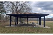
Black Rock Picnic Shelter, CT
Description
Tucked into the scenic rolling hills of the Western Highlands, 439-acre Black Rock State Park offers a variety of outdoor activities. Steep, wooded ledges covered with pine, hemlock and oak provide the setting for Black Rock Pond. The name "Black Rock" is derived from the local graphite deposits which the early settlers of the Naugatuck Valley were allowed to mine by the resident Indians around 1657. Visitors can enjoy the scenery of the Western Highlands while hiking the blue-blazed Mattatuck Trail, which connects the park to the woodland sections of the Mattatuck State Forest.
Book a Campsite at Black Rock Picnic Shelter, CT
Description
Tucked into the scenic rolling hills of the Western Highlands, 439-acre Black Rock State Park offers a variety of outdoor activities. Steep, wooded ledges covered with pine, hemlock and oak provide the setting for Black Rock Pond. The name "Black Rock" is derived from the local graphite deposits which the early settlers of the Naugatuck Valley were allowed to mine by the resident Indians around 1657. Visitors can enjoy the scenery of the Western Highlands while hiking the blue-blazed Mattatuck Trail, which connects the park to the woodland sections of the Mattatuck State Forest.
Geography:
Black Rock was given to the people of Connecticut in 1926, through the efforts of Black Rock Forest, Incorporated, a citizen's conservation group interested in woodland preservation. Development of access roads and facilities later became part of the Civilian Conservation Corps' economic recovery program in the 1930's, following World War I.
Recreation:
Black Rock is a designated Trout Park, so one important activity at the park is stream and pond fishing. Other activities include camping, picnicking, swimming, and field sports. Excellent hiking is available on the Mattatuck Trail, from the Grey Stone section of Waterbury to the Wigwam Reservoir in Morris. This trail offers a scenic view of the Naugatuck Valley, highlighting Black Rock. There are many side trails, where one can see Black Rock Lake, Black Rock Pond, mature forests, and meadows. Hikes can last from 30 minutes to all day.
Facilities:
Black Rock a wooded setting, beach and swimming pond, from May until September 30. Other park facilities include restrooms, a food concession stand and camp store, picnic tables, dumping station, flush toilets, showers, and gravel and grass parking. Firewood and ice are available at the camp office.
Nearby Attractions:
Nearby state parks include Burr Pond State Park, in Torrington, Mt. Tom State Park, in Litchfield, and Topsmead State Forest, also in Litchfield.
Reservations must be made 2 Day(s) ahead of arrival and can be made up to 11 Month(s) in advance.
Season Schedule
- ADA Accessible
- Bird Watching
- Dump Station
- Fire Rings
- First Aid Kit
- Fishing - Freshwater
- Grills
- Hiking
- Mountain Biking
- Parking
- Photography
- Picnic Area
- Picnic Shelter
- Picnic Tables
- Public Drinking Water Taps
- Restroom
- Swimming
- Walking
- Wildlife Viewing
41.65, -73.09
41°39'0"N, 73°5'24"W
From Route 8 north, take Exit 38. Turn left at the end of the exit ramp to the first traffic light. Turn left at the traffic light onto US Route 6 west. Park entrance is 1/2 mile up, on the right, on US Route 6.
Nearby Parks


